Name: ______________________
Date: ______________________
Sunspot Classification
People like patterns. When we see a pattern, we can generally figure out what comes next. Scientists have been classifying sunspots for many years and in many ways. One method of classification, the Zürich Method of Sunspot Classification, was devised in 1938 by M. Waldmeier. In this activity, you will use a modified version of the Zürich Method to classify sunspots.
Vocabulary:
|
Umbra |
The darkest, coolest portion of a sunspot |
|
Penumbra |
The lighter, warmer area surrounding the umbra of some sunspots |
|
Pore |
A dark spot on the Sun, essentially a sunspot umbra with no penumbra |
|
*Unipolar group |
A single spot or a single compact cluster of spots with the greatest distance between two spots of the cluster not exceeding three heliographic degrees. |
|
*Bipolar group |
Two spots or a cluster of many spots extending roughly east-west with the major axis exceeding a length of three heliographic degrees. |
*Source: Solar Geophysical Data, 474 Supplement, Feb1984, pp. 21-23,
US Dept of Commerce, Boulder CO 80303, USA
Procedure:
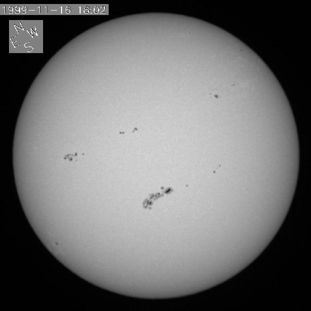
There are several neat sunspots and sunspot groups in this image. How do scientists classify all of these sunspots? Today, scientists use a combination of visual and magnetic characteristics. Take a look at the following table. It’s a classification scheme you can use to classify sunspots and sunspot groups, based on their visual appearance.
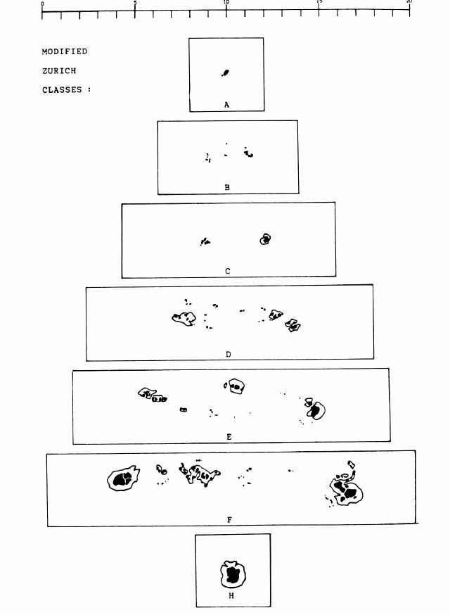
MODIFIED ZÜRICH CLASSIFICATIONS
|
Class A |
Individual spots or groups of spots that:
|
|
Class B |
Spot groups that:
|
|
Class C |
Spot groups that:
|
|
Class D |
Spot groups that:
|
|
Class E |
Spot groups that:
|
|
Class F |
Spot groups that:
|
|
Class H |
Individual spots or spot groups that:
|
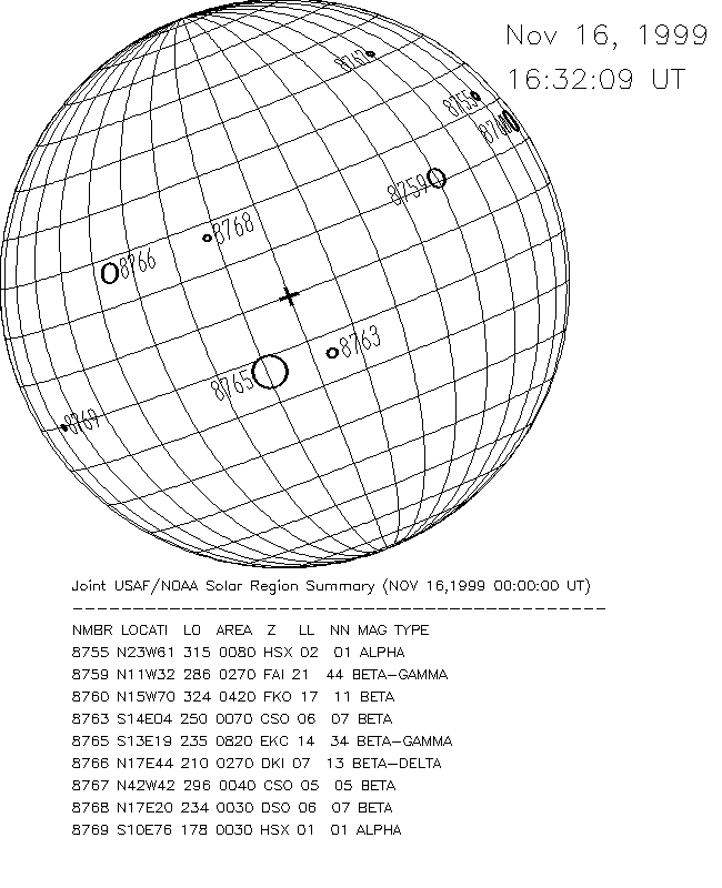 Hawaii. The data for this image were obtained on the same date as the white light image you viewed above. For this type of map, sunspot data are collected and plotted on a Stonyhurst grid. Notice that each sunspot or sunspot group is given an official number (by the National Oceanic and Atmospheric Administration, NOAA) and location. Also notice that there’s more data on the page than you need (the LO, Area, Z, LL, NN, and Mag TYPE). The latitude and longitude lines on this map are spaced at 10°
intervals. Use the information from the BBSO image, the modified Zürich Classifications, and the examples of modified classes, to classify each sunspot group called out in the table below.
Hawaii. The data for this image were obtained on the same date as the white light image you viewed above. For this type of map, sunspot data are collected and plotted on a Stonyhurst grid. Notice that each sunspot or sunspot group is given an official number (by the National Oceanic and Atmospheric Administration, NOAA) and location. Also notice that there’s more data on the page than you need (the LO, Area, Z, LL, NN, and Mag TYPE). The latitude and longitude lines on this map are spaced at 10°
intervals. Use the information from the BBSO image, the modified Zürich Classifications, and the examples of modified classes, to classify each sunspot group called out in the table below.
|
Number |
Single or Group? |
Unipolar or Bipolar? |
Penumbra? |
Length ( ° ) |
Classification |
|
8759 |
|||||
|
8763 |
|||||
|
8765 |
|||||
|
8766 |
|||||
|
8768 |